The first big Arctic Blast of the season is coming next weekend. And, it will be big.
This winter season has been nothing short of cold. One snowstorm after another. This season is no shortage of snow already this winter, but we really haven't had a real deal Arctic Blast yet.
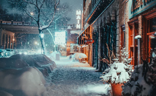
The arctic blast that settled over much of the U.S. has delivered frigid temperatures, snow, ice, and piercing winds that have broken records and should continue breaking records.
The strong cold wind is building up in Canada and is predicted to blast south into Oklahoma this next Saturday. There might be some rain changing to snow on Saturday as the initial cold front comes in on Saturday. Then the coldest air of the season so far follows the front into next week.
But what exactly is an arctic blast?
Related Article: How Do Experts Measure Snow in Mountains?
Arctic Blast
An arctic blast has alternate names for weather fronts called a polar vortex or a blue norther. A polar vortex is a low-pressure area that typically forms around the North and South Poles, strengthening and weakening year over year. A strong vortex generally is a well-defined cold front that is contained and bordered around the arctic regions. AccuWeather defines a blue norther as a "strong cold front marked by a sudden and drastic decrease in temperature."
There are several things the polar vortex is NOT. Polar vortexes are not something new. The term "polar vortex" has only recently been popularized, bringing attention to a weather feature that has always been present. It is also not a feature that exists at the Earth's surface. Weather forecasters examine the polar vortex by looking at conditions tens of thousands of feet up in the atmosphere; however, when we feel the freezing air from the Arctic regions at Earth's surface, it is sometimes associated with the polar vortex. This is not confined to the United States. Portions of Europe and Asia also experience cold surges connected to the polar vortex. By itself, the only danger to humans is the magnitude of how cold temperatures will get when the polar vortex expands, sending Arctic air southward into areas that are not typically that cold.
Weaker vortexes are more scattered and disorganized fronts that can push farther south or north, depending on which pole the front comes out of. These weaker vortexes lead to cold fronts that can combine cold temperatures, winds, and possibly snow.
In 2019, the arctic blast that 240 million Americans have contended with over a good number of days. The Midwest and Northeast have faced the brunt of the blast since it hit then as temperatures began dropping sharply while some got buried under early season snow. This sharp and immediate drop resulted in traffic problems, delayed or canceled flights, and school closures across states like Michigan, Ohio, and Illinois.
The worst has been a series of car accidents across the Midwest, resulting in four confirmed deaths in separate accidents.
Getting Ready
In case of facing intense winters, the following would be the best precautionary measures:
- Prevent pipes from freezing;
- Insulate walls;
- Clear chimneys, vents, and other exhaust ports;
- Maintain a sound heating system;
- Terminate rodents and other pests in the house;
- Have emergency supplies; and
- Prepare a transport vehicle and emergency route
ALSO READ: Snowmageddon: Polar Vortex Split May Result to Weeks of Intense Winter
For more Environmental news update, don't forget to follow Nature World News!
© 2026 NatureWorldNews.com All rights reserved. Do not reproduce without permission.


