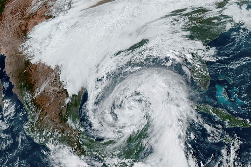
Hurricane Zeta continues its passage as a tropical storm while rapidly moving through the Gulf of Mexico. It is expected to steer northward on Tuesday night.
At 10 PM, it had winds with a speed of 70 mph. It is moving in a northwesterly direction going at 15 mph, shifting slightly westward.
Landfall in Louisiana
Hurricane Zeta is forecast to make its landfall on Louisiana's coast by Wednesday evening with a hurricane Category 1 or almost Category 1 status, with maximum wind speeds almost reaching 85 mph.
The National Hurricane Center or NHC reported that the areas starting from Morgan up to the Alabama and Mississippi border are still hurricane watch. These areas include metropolitan New Orleans, Lake Maurepas, and Lake Pontchartrain.
The western and eastern parts, such as the borders of Mississippi & Alabama, Walton and Okaloosa County, including Morgan to Intracoastal City, are currently under a tropical storm watch.
There are expected to be tropical rain-force wind impacts this Wednesday, as long as the storm's track continues and moves to southeastern Louisiana.
Similar track with Hurricane Delta
Zeta formed last Monday when it headed to the Yucatan Peninsula. It took a similar track with Hurricane Delta, and struck near Mexico in Cozumel, then headed to the northern Gulf Coast.
On Monday night, Zeta was approximately 45 miles in the south-southeast from Cozumel, having winds with a maximum speed of 80 mph, according to the NHC. It moved northwest at a rate of 12 mph.
Zeta was predicted to be a low-end type hurricane and not as strong as Delta. Just like Delta, it could weaken on land briefly.

Behavior in the tropics
As of 10 PM evening Tuesday, Zeta, a tropical storm, was located 390 miles at the south-to-southwest area from the Mississippi River's mouth, having sustained winds with a maximum speed of 70 mph while moving northwest at a rate of 15 miles per hour.
After it made its first landfall in the Yucatan area, the storm now moves across the south from the Gulf of Mexico. Forecasters predict it will come back to hurricane strength while rapidly approaching the Gulf Coast.
A cold front will then curve Zeta towards the northeast before making landfall on Wednesday's late afternoon. It is then expected to move inland at the extreme southeast of Louisiana and the Mississippi coast to then rapidly pull away out of the area by Thursday at midnight.
Forecast for the coming hours and days
From the thick cloud cover and Zeta's tropical moisture as it surges north, ambient temperatures will remain in the 70's overnight. Intermittent thunderstorms and showers are possible, and in the metro area of Baton Rouge, there are expected periods of rains with breezy conditions on Wednesday.
Rainfall is at one to two inches and is possibly manageable in most areas, with three or more inches east of and along the I-55.
Some parts could have some flooding due to higher rainfall, possibly exacerbated by poor drainage. As Zeta passes Wednesday afternoon to night time, wind gusts with a speed of 40 to 50 mph with two to four feet of coastal flooding are possible, especially at the east and south parts of Baton Rouge. Power outage and tree damage are possible in some areas but are not expected to be as widespread as Delta's destruction.
Hurricane warnings have been announced for the areas of Assumption, Ascension, Livingston, Tangipahoa, and St. James Parishes. Meanwhile, tropical storm warnings have been announced for Pike County, St. Mary, and St. Helena Parishes.
Finally, conditions are expected to improve by Thursday when a cold front arrives. The tropical storm and Hurricane Zeta leaves after its passage to Louisiana, which started from the Yucatan, Cozumel, to the Gulf of Mexico.
Check out more news and information on Climate Change on Nature World News.
© 2026 NatureWorldNews.com All rights reserved. Do not reproduce without permission.


