Derecho, a rare storm packed with 100mph winds and power like that of a hurricane, slammed across the Midwest on Monday. The storm toppled trees and powerlines, flipped vehicles, caused widespread damage of properties, and left thousands of homes without power. It continued to move towards Chicago, Indiana, and Michigan.
The National Weather Service Storm Prediction Center raised a particularly dangerous situation severe thunderstorm watch eastern Iowa, northern Illinois, extreme northwest Indiana and southern Wisconsin. Earlier that day, violent storms struck east Nebraska and western Iowa.
Northern Illinois University meteorology professor Victor Gensini said that the recent Derecho is one of the strongest in recent history and will be among the nation's worst weather events for 2020.
READ: Kiribati President Plans to Raise Islands to Address Sea Level Rise
Widespread Damage
As of Monday evening, more than one million people had no power. The storm also caused substantial damage in Indiana and Ohio.
Chicago Midway Airport recorded a gust of 72 mph. O'Hare International Airport also recorded 62 mph gust, while the Weatherbug station in Lincoln Square, Chicago, had a wind gust of 85 mph. The storm left felled trees and powerlines, blocking Chicago roadways and suburbs.
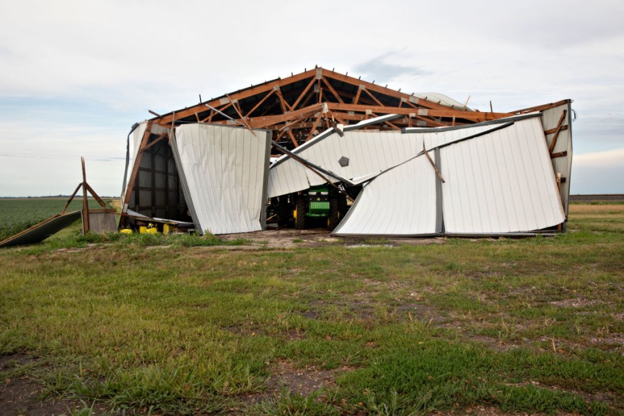
Iowa was the hardest hit. Most areas had wind gusts of 75 and mph, but some locations had wind gusts of more than 100 mph. In Illinois, wind gust was at 92 mph near Dixon.
Several people were injured in Iowa, and damage on properties are prevalent. The winds toppled trees, flipped cars, felled down power lines, and tore road signs and roofs of buildings. In Marshall County, Mayor Joel Greer declared a civil emergency, as he urged residents to stay at home and away from the streets so that responders could respond to calls.
An eyewitness in Cedar Rapids, Iowa, described the event as "utter destruction". Interstate 35 and other roads had to be closed due to overturned vehicles and several damages from the storm.
Derecho was predicted to generate large waves and cause high water ashore. The National Weather Service raised a lakeshore flood warning.
READ ALSO: Mauritius Citizens, Groups Try to Contain Oil Spill to Protect Coastline and Mahebourg Lagoon
Treat Derecho Warnings Like a Tornado
The Chicago Weather Service office warned residents to treat warnings like a tornado warning. The agency emphasized that Derecho is an extremely dangerous line of storms, and urged residents to head for a safe shelter indoors and away from the windows.
As the winds were headed towards downtown Chicago, a city with many skyscrapers, the Weather Service advised residents to stay away from windows and head indoors immediately if walking near high rise buildings.
A derecho is different from a hurricane. It is a widespread, prolonged wind storm that is mostly associated with moving showers and thunderstorms.
Unlike the hurricane, it does not have an eye, and its winds come across in a line. According to Patrick Marsh, science support chief at the National Weather Service's Storm Prediction Center in Norman, Oklahoma, the damage of Derecho is more widespread. He likened it to an inland hurricane than a powerful tornado. The strongest Derecho, known as Super Derecho in 2009, traveled over 1,000 miles in 24 hours, leaving $500 million worth of damages, killing nine people, and injuring dozens.
IN CASE YOU MISSED IT: Isaias Update: Death Toll at 9, Millions Worth of Damages after Hitting East Coast
© 2026 NatureWorldNews.com All rights reserved. Do not reproduce without permission.


