Ever wondered what the Earth looked like when oceans are emptied?
A recent remake of a NASA video from 2008 showed that the hidden three-fifths of Earth's surface would be revealed if all the oceans were drained away. The remade video featured the world's longest mountain range and the ice age land bridges, where ancient humans walked on to migrate to various places. Removing the oceans presented a picture of the world of ancient humans.
The video animation was re-created by Dr. James O'Donoghue, who previously worked at NASA but now works for JAXA, the Japanese Space Agency.
Dr. O'Donoghue's work was inspired by Horace Mitchell's original animation in 2008. Mitchell is a physicist and animator at NASA. O'Donoghue's version has modified timing and features a tracker to show the amount of water drained.
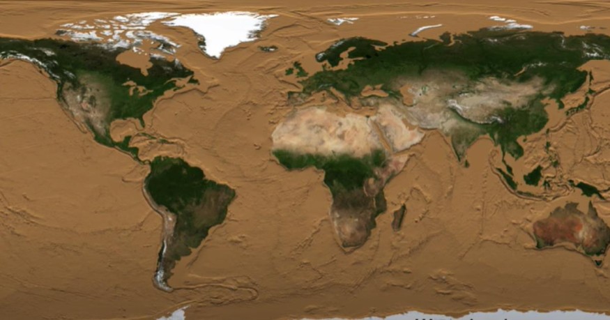
The video starts with the map of the Earth as it appears in the present day. The oceans are then drained every second.
WATCH HERE: Footage of the Last Tasmanian Tiger in Captivity
The first to emerge are the continental shelves--the edges of each continent beneath the sea. The continental shelves are most visible as oceans drop to 140 meters.
These continental shelves include land bridges that ancestors walked through thousands of years ago as they moved from continent to continent.
As the ocean water drops, the first land bridge to emerge is the land bridge that connected mainland Australia with Tasmania and New Guinea. Doggerland, the land bridge between the UK and Europe, was inhabited by ancestors thousands of years ago.
It stretched from Scotland to Denmark and then down to the English Channel. It was also known as "Britain's Atlantis." However, about 8,200 years ago, the place was struck by a tsunami killing tens of thousands of people.
READ THIS: Global Warming Is Causing Stronger Tropical Cyclones, Says New Study
The Bering Strait was a continental shelf between Alaska and Russia, which allowed ancient ancestors to migrate to the Americas from East Asian during the last Ice Age.
According to O'Donoghue, these land bridges were possible because when the last ice age occurred, a vast amount of ocean water was frozen at the poles of the planet. These land bridges made migration possible. When the ice age ended, the waters increased and sealed these land bridges.
The animation features the world of ancient ancestors: the Earth's longest mid-ocean ridge, which showed when the sea levels were drained to 2,000 to 3,000 meters. The said chain of mountains stretched over 37,000 all over the globe, and over 90 percent of which is underwater.
In places where the Earth's tectonic plates move away from each other, volcanic mountains emerge, thereby generating new ocean floors as molten rock grows below the crust.
Most of the water is gone as the oceans drain at 6,000 meters. However, it takes 5,000 meters to clear the water from the Marianas Trench.
The ocean floor, according to O'Donoghue, just like the continents, is just as "variable and interesting in its geology."
© 2026 NatureWorldNews.com All rights reserved. Do not reproduce without permission.


