As the Philippines' Taal Volcano unrest entered its 2nd week, government volcanologists reiterated that evacuees are strongly advised to remain out of the danger zone as Alert Level 4 remains raised.
The Philippine Institute of Volcanology and Seismology (Phivolcs) underscored on Monday, January 20, that scientific records showing a risky eruption remain possible "in hours to days."
Phivolcs Director Renato Solidum Jr, in a press briefing on Monday morning, stated they provide recommendations primarily based on what they monitor, and what the possible risks are. He underscored that management decisions are up to the local authorities of Batangas.
Some citizens try to go back to their homes regardless of the risks; however, several cities in the area are on lockdown.
As of 6 am (local time) Monday, the National Disaster Risk Reduction and Management Council stated that 104,377 people are staying in evacuation centers. At the same time, 68,755 others were displaced outside evacuation centers.
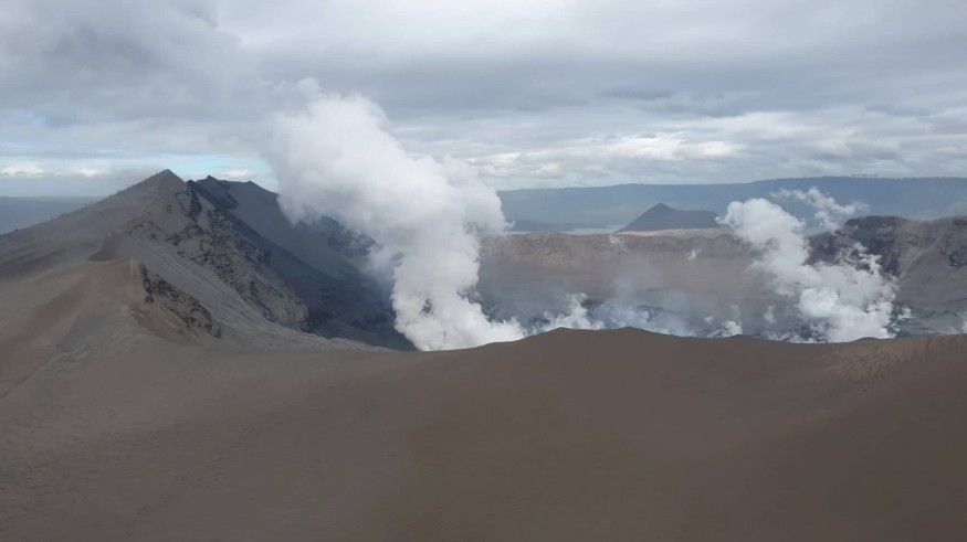
Phivolcs said in its 8 am bulletin on Monday, that "constant" emission continues to release from Taal's main crater.
"Activity in the main crater in the past 24 hours [released] steady steam emission, infrequent weak explosions which generated ash plumes 500 to 1,000 meters tall, and dispersed ash southwest of the main crater," the Phivolcs said.
The sulfur dioxide (SO2) emission, meanwhile, was measured at an average of 4,353 tons every day. SO2 is a major gas component of magma, according to Phivolcs. According to USGS, sulfur is "launched from a volcano while magma is tremendously near the surface."
Volcanic earthquakes also continue. Philippine Seismic Network, which covers the whole country; and the Taal Volcano Network, which incorporates small earthquakes undetected by the former, are being used by Phivolcs to detect volcanic eruptions.
The Philippine Seismic Network has plotted 714 volcanic earthquakes as of 1 pm on January 12, the day the Taal unrest began. Of these, 176 were at magnitudes 1.2 to 4.1 and have been felt at Intensities I to V.
At least 23 volcanic earthquakes plotted at magnitudes 1.2 to 3.8, with one felt at Intensity I from 5 am on Sunday, January 19, to 6 am on Monday.
The Taal Volcano Network, on the other hand, recorded 673 volcanic earthquakes for the past 24 hours.
"Such extreme seismic activity probably signifies non-stop magmatic intrusion below the Taal edifice, which may lead to further eruptive activity," Phivolcs said.
Phivolcs burdened that there have to be "general evacuation" of Taal Volcano Island in addition to high-danger areas within a 14-kilometer radius from the principal crater and "alongside the Pansipit River Valley wherein fissuring has been observed."
Fissures or cracks had appeared in the towns of Lemery, Agoncillo, Talisay, and San Nicolas in Batangas, which are all high-risk regions. Ground deformation is considered one of the signs that magma is rising in the volcano.
Citing the weather forecast given by Philippine Atmospheric, Geophysical, and Astronomical Services Administration (Pag-Asa), Phivolcs said ash would be drifted to west and southwest of the main crater if the eruption plume remains below three kilometers.
Ash will also go with the flow to elements of neighboring Cavite province if the eruption plume is 3 to 5 kilometers high.
Phivolcs said ash would also be drifted over Metro Manila, Laguna, and some parts of Rizal and northern Quezon if the main eruption happens for the duration of the day and the eruption column exceeds 5 kilometers.
So far, the cost of agricultural damage inside the place of Calabarzon is pegged at P3.06 billion. Ashfall destroyed numerous crops.
© 2026 NatureWorldNews.com All rights reserved. Do not reproduce without permission.


