A challenging weather outlook is likely in the Atlantic and Gulf Coasts, according to a weather report. People should stay alert for signs of widespread damaging winds, hail, and isolated tornadoes.
Travelers should keep updated with the latest forecasts this week to avoid potential weather threats, especially tornadoes. A National Weather Service (NWS) report warns of nighttime tornadoes, including a Tornado Watch and Tornado Warning.
The NWS forecast monitors the development of active severe weather in the southern and central Plains. Critical fire weather risks can occur in New Mexico, Texas, Oklahoma, and Colorado.
Commuters should stay alert for severe thunderstorms and long-track tornadoes. Staying aware of approaching severe weather is advisable to keep safe from outdoors.
Severe Weather Threats in Gulf Coast and Atlantic

According to a weather report, over 125 million Americans are at risk of severe weather outlook, warning of poor outlook in the eastern and southern U.S. The threat is likely midweek, causing flash flood concerns, widespread damaging winds, and hail conditions.
An NWS Weather Prediction Center report reveals a rapidly intensifying cyclone in the northern High Plains. A risk of excessive rainfall can unload in the Middle Mississippi Valley.
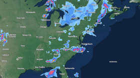
On Wednesday, severe thunderstorms can hit the following areas:
- Dallas
- Huntsville
- Little Rock
- Jackson
- Mobile
- Nashville
- Atlanta
- Charleston
- Wilmington
- Raleigh
- Richmond
- Washington
The challenging weather conditions can likely affect areas from New Jersey to central Texas, including parts of the Carolinas. On Thursday, the weather pattern will change, bringing building heat and humidity in the following areas:
- Washington
- Charlotte
- Jacksonville
- Miami
- Houston
- Dallas
- Memphis
Meanwhile, NWS Houston reports minor to significant river flooding, which is likely due to potential rainfall. Flooding concerns can unload in the Trinity, San Jacinto, and Navasota rivers. People in low-lying communities are more vulnerable to river flooding risks.
The advisory reveals that multiple rounds of rainfall could occur in Little Rock on Tuesday or Wednesday. In midweek, residents can likely experience hot and humid conditions in Arkansas, including isolated tornadoes.
For Jacksonville residents, possible scattered thunderstorms are likely, and gusty winds could reach 40 to 50 mph. Frequent lightning and heavy rainfall can also unload.
Also Read: Utah & Colorado Weather Forecast: Storm System Likely to Bring Scattered Showers, Thunderstorms
Severe Weather Preparedness This Week: How Can People Stay Safe?
The latest weather report warns of poor weather conditions in parts of the Gulf Coast and Atlantic, causing slower commutes and power outages. People with travel plans should check the road conditions before leaving, particularly in central and southern Plains.
Driving slowly and maintaining distance from other vehicles is advisable to prevent potential road hazards. For homeowners, storing emergency kits is essential, including the following:
- battery-powered radios
- flashlights
- bottled water
- canned goods
Related Article: US Severe Weather Outlook: Heavy Rains, Thunderstorms Likely in Southern Texas, Mid-Mississippi Valley This Week
For more similar stories, don't forget to follow Nature World News.
© 2024 NatureWorldNews.com All rights reserved. Do not reproduce without permission.