An active weather pattern is threatening parts of the Central United States. According to the latest US weather forecast, the National Weather Service (NWS) warns that the weather system may cause severe thunderstorms that can produce isolated or strong tornadoes, as well as strong winds and large hail. Furthermore, there is a risk of flooding due to heavy rain expected to impact the region.
As the US spring season progresses on its second month, multiple severe storm events have occurred in different parts of the country since March 2024. Some severe weather incidents brought deadly tornadoes, including in the US Gulf Coast states, where multiple people died earlier in April 2024. Now, renewed thunderstorms may bring disruptive and life-threatening risks for millions of people.
Active Weather Pattern

(Photo : Photo by Alex Dukhanov on Unsplash)
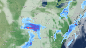
In its recent short-range weather forecast, the NWS' Weather Prediction Center (WPC) at 3:28 a.m. EDT (local time) on Friday, April 26, warns that the active weather pattern will impact most parts of the Great Plains and into the central/northern Mississippi Valley regions. The hazards include localized flash flooding due to heavy rain and thunderstorms in portions of the Plains.
Potential flooding events are also possible for parts of the Mississippi Valley, with very large hail reaching up to 3 inches in diameter expected on Friday evening across western Kansas. Adverse weather conditions may continue during the weekend not only in the Central US but also in its surrounding regions, which also experienced inclement weather over the past week.
The weather pattern may cause disruptions such as power outages and flight delays or cancelations. In addition, potential tornadoes are also possible amid severe thunderstorms. In late March, severe weather spawned a tornado outbreak across the lower Mississippi River Valley of the US, resulting in the deaths of 21 people from an initial death toll of 25, as stated by Governor Tate Reeves.
Also Read: South-central US Weather: Floods May Resurface Due To Severe Weather
Fire Weather Conditions
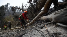
Aside from the looming stormy weather, the NWS is also forecasting critical fire weather conditions across the southern High Plains, which includes the Texas panhandle. This means that weather and climatic conditions will be favorable to the growth and spread of wildfires across the region. Earlier this year, it can be recalled that Texas experienced its worst wildfire in history, called the Smokehouse Creek Fire.
According to US meteorologists, fire weather is a meteorological term that pertains to relative humidity, wind speed, wind direction, soil moisture, and mixing heights. These parameters are used to determine if weather conditions are favorable for fire growth and smoke dispersion, the US Government weather agency explains.
Since the US is currently in its spring season, warm temperatures and dry conditions are likely to contribute to the eruption of fire, whether they are caused by natural factors or human-induced activities. Moreover, the NWS is forecasting the occurrence of elevated to critical fire weather across the southern High Plains this weekend.
Related Article: South-Central US Weather Forecast: Rounds of Heavy Rain to Bring Renewed Flood Risk
© 2024 NatureWorldNews.com All rights reserved. Do not reproduce without permission.

![Wildfire Activity in Wet African Tropical Forests Exacerbated by Deforestation, Climate Change [Study]](https://1471793142.rsc.cdn77.org/data/thumbs/full/70409/280/157/50/40/wildfire-activity-in-wet-african-tropical-forests-exacerbated-by-deforestation-climate-change-study.jpg)