Severe thunderstorms are looming in some parts of the Eastern United States this week, causing potential disruptions and life-threatening risks, especially for travelers. On Monday, April 15, the National Weather Service (NWS) issued a severe thunderstorm alert, warning for potential tornadoes, damaging winds, and large hail.
This comes as the adverse weather system will continue to develop across the upper Ohio Valley and into the interior Northeast US regions.
The US is already more than a month into its spring season, which saw increased occurrences of severe storms with some accompanied by deadly tornadoes. Earlier in April, a tornado outbreak that struck the US Gulf Coast led to the deaths of 14 people from Texas to Florida, according to local reports.
Multiple injuries were also reported amid the severe weather last week, which also damaged infrastructure across the region.
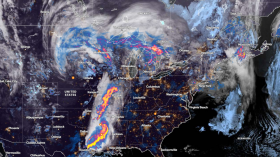
Severe Thunderstorm Alert
![Severe Thunderstorm Alert: Tornadoes, Damaging Winds and Hail Possible from Upper Ohio Valley to Northeast US [NWS]](https://1471793142.rsc.cdn77.org/data/images/full/70161/severe-thunderstorm-alert-tornadoes-damaging-winds-and-hail-possible-from-upper-ohio-valley-to-northeast-us-nws.jpg?w=820 "Severe Thunderstorm Alert: Tornadoes, Damaging Winds and Hail Possible from Upper Ohio Valley to Northeast US [NWS]")
(Photo : Photo by Jari Hytönen on Unsplash)
A severe thunderstorm alert has been issued by the weather service on Monday, highlighting the risk of thunderstorm-driven twisters, strong winds, and balls of ice. At 3:58 a.m. EDT (local time), the NWS' Weather Prediction Center (WPC) provided a US severe weather forecast about the intensifying storm system, which can also bring the risk of flash flooding due to possible heavy rain.
Based on the weather alert, scattered thunderstorms are expected from the upper Ohio Valley to the Mid-Atlantic region in the east. The WPC adds that the storms will progress eastward along with a frontal system from Monday evening to Tuesday, April 16, spreading to the Mississippi Valley, Great Lakes, and Ohio Valley.
Power outages and flight delays or cancelations are possible in the coming days in the affected regions. Additionally, severe weather can result in damage to infrastructure, including roads and buildings, during a tornado outbreak.
Also Read: US Storm Warning: SPC Issues Severe Thunderstorm Alert for States in the Gulf Coast and Midwest
US Weather Forecast
Aside from the lingering severe storms, the NWS expects the continuance of warmer temperatures for most areas of the Central US and Eastern US on Monday.
This is because an upper level is preceding a low-pressure/frontal system over the Western US, where multiple, late-season winter advisories and warnings are in place for high-altitude areas. Yet, extreme blizzard conditions are not expected across the West.
In terms of long-range US weather forecast, the National Oceanic and Atmospheric Administration (NOAA) on April 2 predicted the likely chance for a "warm April" across the Upper Midwest and western Great Lakes region.
In addition, no areas will experience above-average cold temperatures. Furthermore, a wet April is highly possible in the upper Ohio Valley.
Moreover, the NOAA says that the April temperature outlook shows relatively warmer temperatures across the northern tier of the US, spanning from the Pacific Northwest to northern California and eastward to the northern Rockies and Great Plains.
Other regions such as from the Plains to the Great Lakes, Northeast, and Mid-Atlantic will experience similar warm weather.
Related Article: Thunderstorm Alert: Severe Weather Forecasted from Southern Plains to Southeast US This Week [NWS]
© 2024 NatureWorldNews.com All rights reserved. Do not reproduce without permission.


![Climate Change is Reducing Dust Levels Worldwide as Arctic Temperature Warms [Study]](https://1471793142.rsc.cdn77.org/data/thumbs/full/70320/280/157/50/40/climate-change-is-reducing-dust-levels-worldwide-as-arctic-temperature-warms-study.jpg)