Central US can likely experience threats of severe weather outlook, according to a latest weather report. The forecast warns of strong winds, isolated tornadoes, and hail this early week, bringing potential power outages and slower commutes.
Recently, the weather report revealed severe thunderstorm threats from the Midwest to the Northeast, causing possible flash flooding, tornadoes, and localized damaging winds in parts of New York, Pittsburgh, Columbus, Cleveland, and Erie. Rainy concerns also occurred in Burlington and Boston.
In addition, the National Weather Service (NWS) warns of enhanced risk of severe weather in portions of Nebraska and Kansas, causing potential large hail risk. Widespread thunderstorms can threaten Upper Ohio and Southern New England, with risks of tornadoes and strong winds.
In Kansas City, the rounds of storms can hit Monday night or Tuesday. Homeowners are advised to keep alert for hail conditions and damaging winds. People with travel plans should stay updated with the latest forecasts to avoid potential travel dangers. Portions of western Oklahoma and Western North Texas can experience a challenging weather outlook.
Weather in the Central US: Where Will Troublesome Weather Unload?
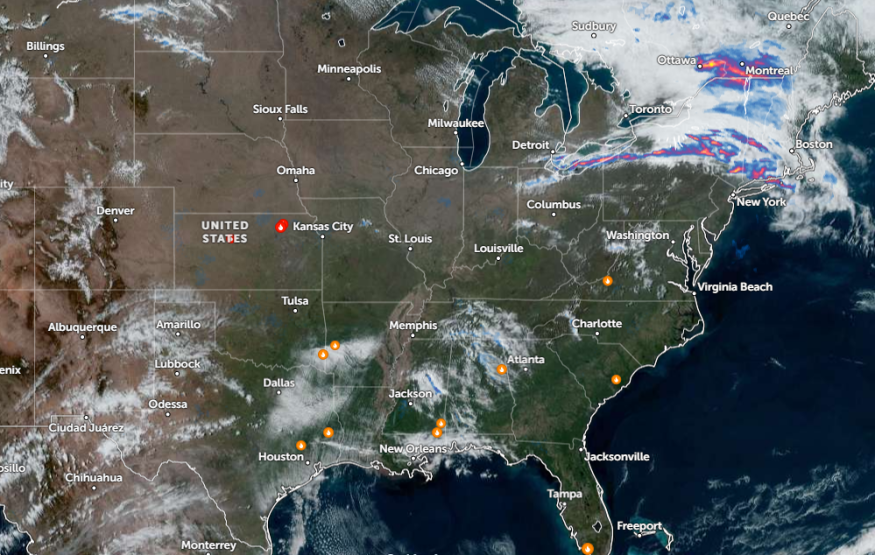
According to the forecast, strong winds and tornado risks can strike Central US this early week. The mid-April can bring severe weather concerns in the region, including in the Plains and Midwest. The latest weather advisory warns of rounds of rain with thunderstorms in Minneapolis, Chicago, Kansas City, Dallas, Memphis, and Houston.
Travel risks are likely due to the weather, particularly in the Central US and Midwest. For motorists, checking the road conditions is advisable to keep safe from the weather. When storms become severe, it is best to stay at home until the weather finally improves.
In addition, flooding rainfall can unload with strong winds. Communities in flood-prone areas are vulnerable to small to moderate flooding concerns. On Monday night, severe thunderstorms can bring hail, isolated tornadoes, and heavy downpours. The severe weather threat can occur in Sioux Falls, Lincoln, Wichita, Amarillo, Kansas City, Amarillo, Wichita Falls, and Abilene.
In Chicago, the advisory shows a dry and mild outlook this early week. On Tuesday, homeowners can experience potential showers and storms, with a chance of severe weather at night. The advisory warns that the waves of showers will likely transform from being strong to severe.
Severe weather risk can stay until the late week. Staying updated with the latest weather report is advisable, particularly for vulnerable areas. The severe thunderstorm threat is likely in Rochester, Cedar Rapids, Milwaukee, Chicago, Indianapolis, and St. Louis. Springfield, Memphis, and Little Rock.
Also Read : California Weather Forecast: Mix of Rain, Mountain Snow to Bring Dangerous Travel, Flooding Concern
Weather in Parts of California and Intermountain West
On the other hand, the forecast monitors a low-pressure area impacting portions of California mountains and Intermountain West. Residents can anticipate snow showers and scattered rain in the region, spreading over the Ohio Valley and Northeast.
In the Northeast, potential thunderstorms and rain can unload, particularly for eastern Ohio into western and northern Pennsylvania.
Related Article : Midwest Weather Forecast: 75 Million People At Risk of Severe Weather Threat This Week
For more similar stories, don't forget to follow Nature World News.
© 2026 NatureWorldNews.com All rights reserved. Do not reproduce without permission.


