Severe thunderstorms can bring significant risk this week due to potential flooding concerns, hail conditions, strong winds, and isolated tornadoes. Homeowners should watch out for local weather news to stay safe from challenging weather events.
Limiting outdoor plans is recommended due to potential weather dangers. Motorists can expect slippery commutes and a foggy outlook due to severe thunderstorms. In a Nature World News (NWN) report, New York suffered from flooding and heavy rains, resulting in flooded roads, and many residents struggled to commute due to slippery roads.
An enhanced risk of severe thunderstorms can hit portions of the Lower Mississippi Valley on Monday. The Central and Southern Plains can experience a challenging weather outlook, with possible lightning, tornadoes, strong gusts, and hail.
Early next week, a risk of severe thunderstorms can impact portions of the Central and Eastern Gulf Coast, including the Ohio Valley.
Severe Thunderstorm Forecast: Where Will It Impact?

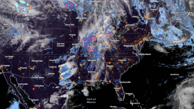
(Photo : Zoom Earth Satellite Forecast) Parts of Mississippi and Gulf Coast can suffer from isolated tornadoes and severe weather threat this week.
According to the latest forecast, tornado threats and severe thunderstorms can unload on the Mississippi Valley and Gulf Coast in the early weeks. On Monday, a rainy outlook is forecast in Memphis, Chicago. Meanwhile, chilly weather can unfold in Boston, New York, Los Angeles, and San Francisco.
In parts of the Southeast, the NWS Weather Prediction Center warns of excessive rainfall and severe thunderstorm threats this week. Last weekend, severe thunderstorm concerns threatened to bring a stormy outlook to Texas, Kansas, southwestern Nebraska, and Oklahoma.
In Kansas City, a wind advisory is in effect on Monday. Rain showers and isolated thunderstorms can occur in the region. On Monday, the wind gusts can reach 40 to 45 mph. Light snow unloads in the early weeks, including in northern Missouri.
Flooding and isolated tornadoes can affect the road conditions in Dallas, Austin, Abilene, Oklahoma, and Wichita. Nocturnal tornadoes are more dangerous, and homeowners should turn on their weather alerts for possible risks.
On Monday, severe thunderstorms can unleash hail, tornadoes, and damaging winds in the following areas:
- Little Rock
- Memphis
- Shreveport
- Houston
- Jackson
- Nashville
- Omaha
- Des Moines
Power outages, infrastructure damage, and flash floods can emerge due to the weather outlook. However, the severe weather threat can unload in Indianapolis, Louisville, Cincinnati, and Fort Wayne.
In Little Rock, the advisory warns of showers and thunderstorms this week. People should check for hazardous winds and scattered showers on Monday. The forecast warns of potential quick spin-up tornadoes this week.
Also Read: Northern New England, NY State Weather Forecast: Heavy Snow to Bring Potential Travel Concerns
Tornado Preparedness in Affected Areas
The latest weather forecast warns of tornado preparedness, particularly in the Mississippi Valley and Gulf Coast. Homeowners should understand the difference between a tornado watch and a tornado warning to avoid potential safety risks,
When a tornado emerges, homeowners should look for safer areas, and it is best to keep away from windows, doors and fragile materials that can break.
Related Article: Northeast to Expect Heavy Snowfall This Weekend; New Storm To Unload in Upper Midwest
For more similar stories, don't forget to follow Nature World News.
© 2024 NatureWorldNews.com All rights reserved. Do not reproduce without permission.