Weather experts said that the spring-like temperatures would be felt in the Southern Plains to the Midwest.
The upcoming week will bring about a pattern shift that is seen to allow warm conditions to spread across the Plains.
Zone Of High Pressure
Meteorologists said that a zone of high pressure centered over the South Central and Midwestern states has already promoted largely dry conditions and gradual warming.
Moreover, high temperatures have started to rise once again on Sunday into the 60s and 70s as far north as Nebraska, Iowa and Illinois. On the other hand, it was in the daytime of late February when temperatures typically trend between the upper 30s and the lower 40s.
The National Weather Service (NWS) said that to the east, already anomalously warm temperatures this weekend over the heart of the country will eventually warm up as it heads towards the work week.
Meanwhile, forecast highs on Monday and Tuesday will soar as much as 30-45 degrees above late February averages. It will feel more like Spring across the Northern and Central Plains and Midwest with highs in the 60s and 70s.
When it comes to the Southern Plains, the conditions will be more early summer-like and downright hot for the month of February. Highs will also range from the low 80s to as hot as the mid-90s in southern Texas.
Meteorologists explained that these highs all across the Plains and Midwest will be at daily record-tying or breaking levels, in some cases by several degrees. A few February monthly records may also be tied/broken.
Meanwhile, the warmth in addition to dry conditions and gusty winds across the Southern High Plains has resulted in a Critical Risk of Fire Weather (level 2/3) from the Storm Prediction Center Monday, which will likely continue towards Tuesday.
While not as anomalous, temperatures will be warming well above average for the East Coast as well, with highs into the 40s and 50s for New England, 50s and 60s for the Mid-Atlantic, 60s and 70s for the Carolinas, and 70s and 80s for the Southeast and Florida.
Read Also: Nocturnal Tornadoes in Central, Eastern US: Severe Thunderstorms to Bring Significant Risk Next Week
Anomalous Warmth
On the other hand, these temperatures will be short lived for some areas as the anomalous warmth makes a cold front associated with the western storm system pushing into the Northern Plains on Tuesday.
This will be much more notable as temperatures plummet into the teens and 20s. Meanwhile, the return to winter will spread further south and eastward Wednesday just beyond the current forecast period.
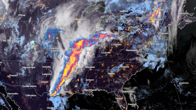
As this storm system over the West continues eastward into the Plains and the Midwest on Tuesday, wherein moist southerly flow ahead of the cold front will bring increasing shower and thunderstorm chances to the Midwest/Great Lakes.
The strong low-level and upper-level dynamics will lead to the risk of some more potent thunderstorms with the potential for some locally heavy rainfall as well as severe weather.
Meanwhile, the Storm Prediction Center has already outlined a slight risk of severe weather (level 2/5) for the risk of large hail, damaging winds, and a few tornadoes.
Weather experts warned that this threat would ramp up on late Tuesday afternoon and continue into the overnight hours, just beyond the current forecast period.
Some moderate snow showers are also possible for portions of the Upper Midwest/Great Lakes in the colder air behind the front.
Related Article: Eastern, Central US Weather Forecast: 50 Million People At Risk of Tornado Threats
© 2024 NatureWorldNews.com All rights reserved. Do not reproduce without permission.
![Tsunami Hazard Zones: New US Map Shows Places at Risk of Flooding and Tsunamis Amid Rising Sea Levels [NOAA]](https://1471793142.rsc.cdn77.org/data/thumbs/full/70325/280/157/50/40/tsunami-hazard-zones-new-us-map-shows-places-at-risk-of-flooding-and-tsunamis-amid-rising-sea-levels-noaa.jpg)


