Weather experts said that wet winter would continue to be felt in California due to new storms.
This will bring additional rounds of floods, gusty winds and heavy Sierra snowfall in the region.
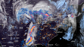
The relentless wet pattern will continue for residents along the West Coast, according to meteorologists.
Stormy Conditions
Based on the forecast, it is through at least the middle of this week that stormy conditions will move onshore in the West and will bring rounds of locally heavy rainfall as well as a renewed risk for floods.
A widespread storm will also bring rain towards the farther south into the coasts of both Los Angeles and eventually in San Diego.
The National Weather Service (NWS) said that moderate risk of excessive rainfall is anticipated along coastal central California through Monday while heavy snow is likely over Sierra Nevada and Mount Shasta in California.
Meanwhile, the warming trend is expected to expand across the Great Plains through the middle of the week.
The new week will begin with a rather potent low pressure system getting ready to deliver the next round of heavy precipitation into the West Coast with focus mainly across California.
The first batch of moderate to heavy rain was forecasted to reach coastal northern California on Sunday. This will be followed by the arrival of the heaviest precipitation associated with the system on Monday.
A couple of inches of rain can be expected to fall across the lower elevations of northern California while coastal central to southern California is expected to receive the heaviest rains totaling a few inches through the next couple of days.
These rains are expected to raise the risk and threat of flash floods to moderate levels in the affected areas.
Read Also: Washington, Philadelphia Weather Forecast: New Brewing Storm Likely This Week
Onslaught Of Heavy Snow
On the other hand, the Sierra Nevada and Mount Shasta will be impacted by an onslaught of heavy snow on Monday, with new snow likely totaling a few feet through the next couple of days.
By Tuesday, both the intensity and coverage of the precipitation are expected to decrease as the system pushes farther inland and weakens.
Nevertheless, much of California will likely receive light to moderate precipitation on Tuesday as southern California is expected to see steadier rainfall moving in.
Meanwhile, elevation-dependent rain and snow associated with the weakened system will spread northeastward across the Great Basin and into the northern Rockies over the next couple of days.
Further, a clipper system sliding across southeastern Canada will only bring limited areas of lake-enhanced snowfall across the lower Great Lakes and interior northern New England through tonight before tapering off Monday morning.
Over Florida, a low pressure system developing over the Gulf of Mexico along a stalled front will traverse towards the Florida Peninsula by this evening before moving out into the Atlantic on Monday.
Generally a couple of inches of rain, with locally higher amounts, can also be expected due to this weather phenomenon.
Related Article: New York Valentine's Day Weather: Chilly Conditions to Continue This Week With Gusty Winds
© 2024 NatureWorldNews.com All rights reserved. Do not reproduce without permission.


![Climate Change is Reducing Dust Levels Worldwide as Arctic Temperature Warms [Study]](https://1471793142.rsc.cdn77.org/data/thumbs/full/70320/280/157/50/40/climate-change-is-reducing-dust-levels-worldwide-as-arctic-temperature-warms-study.jpg)