The Rocky Mountains are on winter alert as a powerful coast-to-coast storm sweeps the country, according to a central US weather forecast.
Central US Weather Overview
A powerful coast-to-coast storm system, following heavy rain and a rare tornado near Vancouver, Washington, is advancing across the central US on Thursday. The severe weather risk now shifts to the Plains as the system moves east.
Showers and thunderstorms are expected, some possibly severe, from the central Plains to the Midwest on Thursday and Friday. The SPC has issued a Tornado Watch for parts of northern Kansas and central Nebraska until 7 PM CDT due to the severe weather threat.
Supercell Thunderstorms, Rare Tornado
The SPC predicts the development of scattered strong to severe thunderstorms in central Nebraska and northern Kansas on Thursday, including supercell thunderstorms with a tornado and large hail potential. On Wednesday, a rare EF-0 tornado briefly touched down in La Center, Washington, causing minimal damage. Washington usually experiences only about three tornadoes annually.
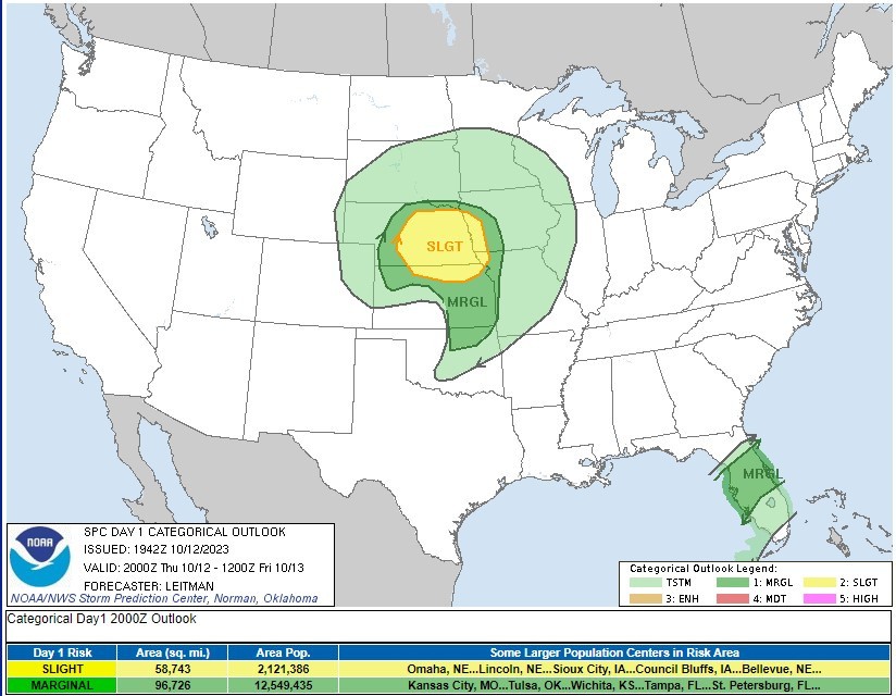
The primary severe weather risk on Thursday lies in the central Plains, with the SPC designating it as a level 2 out of 5 on the thunderstorm risk scale. Cities like Omaha and Lincoln in Nebraska are within this threat zone.
On Friday, the threat shifts eastward, with parts of the Midwest, including Iowa, Illinois, Missouri, and St. Louis, falling under a level 1 out of 5 on the thunderstorm risk scale.
Hailstones, Flash Floods
Late-day ignition of thunderstorms may yield tornadoes and large hailstones, warned Meteorologist Britta Merwin.
Meteorologist Jane Minar highlighted the risk of hail, likening it to ping-pong balls hitting windows. Flash flooding is also a concern as the storm moves east on Thursday and Friday. The central Plains, parts of the Midwest, including southeastern South Dakota, northeastern Nebraska, southwestern Minnesota, and northwestern Iowa, face the highest flash flood threat.
Several inches of rain are expected through the weekend, particularly in the northern Plains and Great Lakes region. Southern South Dakota, Iowa, southern Wisconsin, northern Illinois, and Chicago may see 3 to 5 inches of rainfall, posing potential hazards.
Winter Alerts in the Rocky Mountains
There are other effects of the storm besides rain and bad weather. The Rocky Mountains' higher elevations are also experiencing severe snowfall, and many winter weather alerts are in effect.
The elevation of Salt Lake City, according to Merwin, is about 4,500 feet; about 5,200 feet is Denver. Moving up the slope, at 7,000 feet, snow will be visible, and the mountain passes in Colorado and Utah are above 7,000 feet. Those are rain locations, according to Merwin, who also said that it is all in the elevation.
Also Read : 3°C Rise in Temperature From Human-Induced Climate Change Will Make Central US Uninhabitable
Powerful Coast-to-Coast Storm
The storm moving from the Ohio Valley across the Great Lakes on Saturday will bring rain to the Northeast and New England. Earlier in the week, heavy rain and strong winds threatened to disrupt weekend plans in these regions. Meteorologist Bob Van Dillen initially predicted a complete washout from New England to the mid-Atlantic coast. However, the outlook has improved.
While the storm is expected to strengthen as it leaves the Great Lakes, it might not result in a total washout. Heavy rain is likely in parts of Pennsylvania, including the Philadelphia area, and into Washington DC. The storm is also tracking a bit farther south and moving faster than initially anticipated.
This means that the heaviest rain is likely to be confined to the Jersey Shore and south of Long Island in New York on Sunday. Fortunately, the storm's trajectory is also expected to clear out more quickly. Some rain is possible on Saturday night through Sunday, primarily from the Massachusetts Turnpike southward. Sunday should bring clearing skies and somewhat cooler conditions, offering a better day for the affected regions.
© 2026 NatureWorldNews.com All rights reserved. Do not reproduce without permission.


