Meteorologists said that Philippe, previously a tropical storm, has been transitioning into more of a winter-style storm.
The National Hurricane Center and Central Pacific Hurricane Center said that while Philippe has transformed into a post-tropical, the weather disturbance could still bring risks of flash floods over New England.
Officials in eastern New England and Atlantic Canada should monitor the progress of the post-tropical cyclone for its possible effects.
Further, it will also hit the zone from Maine to New Brunswick and southern Nova Scotia, unleashing flash floods, high winds and coastal flooding as it rolls northwestward toward the region this weekend.
Due to Philippe's track and its transition upon nearing North America, powerful winds that can cause property damage and power outages will be near and to the northeast of the center as it moves ashore from late Saturday to early Sunday.
Meteorologists said that Philippe's interaction with the jet stream would result in an extended period of November-like weather for much of the Northeast and Atlantic Canada next week.
Further, gusty west to northwest winds will add to the chill. This will then follow an extended period of late summerlike conditions much of the week.
Moreover, the occurrence of snow is also included in the forecast for parts of Quebec and upstate New York.
Read Also : Tropical Storm Philippe's Effects To Be Felt In Bermuda, Complex Weather Patterns Expected Over The Weekend
Weather Tracking: What's the Direction?
At 1100 AM AST (1500 UTC), the center of Post-Tropical Cyclone Philippe was spotted near latitude 30.7 North, longitude 64.6 West.
The post-tropical cyclone is tracking the direction towards the north-northeast near 16 mph (26 km/h). A northward or north-northwestward motion at a faster forward speed was foreseen in the next few days.
Meanwhile, in the forecast track, the system will continue passing Bermuda today and will reach the coast of Atlantic Canada or eastern New England over the weekend.
Philippe is packing maximum sustained winds that are near 50 mph (85 km/h) with higher gusts. Meteorologists said that some strengthening is possible over the next day or so.
On the other hand, tropical-storm-force winds extend outward up to 205 miles (335 km) to the east of the center while the estimated minimum central pressure is 1003 mb (29.62 inches).
Strong winds are possible over portions of Atlantic Canada and eastern New England this weekend while the amount of rainfall will be diminishing across Bermuda today. An additional inch or less of rainfall is possible.
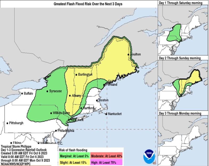
Weather experts said that for portions of New York and New England as well as Southeast Canada, rainfall amounts of 1 to 3 inches, with local maximum amounts of 5 inches, are expected this weekend.
Isolated to scattered instances of urban and flash flooding will be possible in these areas.
Meanwhile, the large swells will continue to affect Bermuda for the next few days. Swells are also affecting portions of the southeastern US coast and will spread northward along the east coast toAtlantic Canada during the next couple of days.
Authorities warned that these conditions are likely to cause life-threatening surf and rip currents.
Residents are then advised to consult their respective local weather offices for updates on the weather.
Related Article : Tropical Storm Philippe Updates: East Maine, Brunswick, Northern New England, US To Receive Heavy Rain this Weekend
Related Video:
© 2025 NatureWorldNews.com All rights reserved. Do not reproduce without permission.


