A low pressure system hovering over the Atlantic Ocean, off the southeast coast of the United States, could intensify into a tropical storm before it moves toward eastern North Carolina by Saturday, September 23. This is according to the latest US weather forecast by the National Weather Service (NWS).
Through the weekend, the approaching system could impact the Mid-Atlantic region with heavy rain, strong winds, storm surge, high surf conditions, and rip currents that can be life-threatening.
The system, also called a tropical cyclone, developed in the Atlantic following the formation of Hurricane Nigel in recent days and Hurricane Lee earlier in September.
The recent Atlantic storms confirm the forecast of the National Oceanic and Atmospheric Administration (NOAA) of an above-average 2023 Atlantic hurricane season. This means that the frequency and intensity of storms and hurricanes are higher than normal.
Low Pressure System
A "dreary weekend" is looming for the Mid-Atlantic as rainfall started and is expected to spread north ahead of the developing low pressure system off the Southeast US, according to the short-range forecast of the NWS' Weather Prediction Center (WPC) on Friday, September 22.
The WPC warned the strengthening pressure system will produce torrential rain, gusty winds, and marine hazards across the region in the coming days.
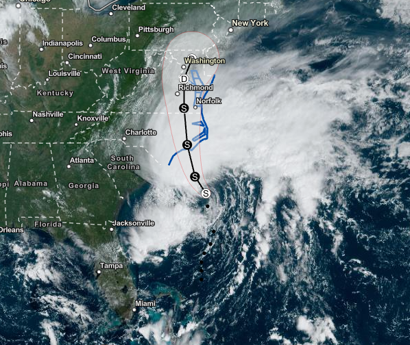
Potential Tropical Cyclone Sixteen
The system has been designated by the National Hurricane Center (NHC) as 'Potential Tropical Cyclone Sixteen' and is expected to intensity into a tropical storm by Friday evening before moving onshore over the coast of eastern North Carolina on Saturday.
According to the NHC, Potential Tropical Cyclone Sixteen has maximum sustained winds of 50 miles per hour, moving in a northward pattern at a speed of 12 miles per hour. Due to the threat, the hurricane center issued 'Tropical Storm Warnings' along some parts of the southeastern and Mid-Atlantic coasts.
Marine Hazards
In the coming hours and days, coastal flooding or coastal erosion is possible due to large waves caused by the tropical system's gusty winds. These marine hazards make it dangerous for beachgoers, fishermen, and even commercial vessels off the Southeast US coast.
In particular, the NWS and NHC warned that coastal flooding due to storm surge is a possibility, especially in coastal areas across eastern North Carolina and southeastern Virginia. Furthermore, heavy rain may occur in the Mid-Atlantic and southern New England.
For North Carolina and Virginia, the NHC specifies some of the areas to are potentially at risk of life-threatening storm surges:
- Pamlico and Albemarle Sounds
- Neuse and Pamlico Rivers
- Lower James River
- Lower Chesapeake Bay
Last week, former Hurricane Lee made landfall as an Atlantic storm in Nova Scotia, Canada. It brought destructive winds and marine hazards to large parts of New England and the coastal waters of eastern Canada, causing flooding and leaving tens of thousands of people without power.
© 2026 NatureWorldNews.com All rights reserved. Do not reproduce without permission.


