Meteorologists said that Hurricane Lee was found to be restrengthening as they warned that hazardous beach conditions are expected in the Western Atlantic.
According to the National Hurricane Center and Central Pacific Hurricane Center, the center of Hurricane Lee was spotted near latitude 22.1 North, longitude 61.7 West. They said that Lee is tracking the direction towards the west-northwest near 8 mph (13 km/h).
Meteorologists further said that a slower west-northwestward motion is expected to occur in the next few days.
On the forecast track, Lee is also seen to move towards north of the northern Leeward Islands, the Virgin Islands, and Puerto Rico during the next day or two.
Category 3
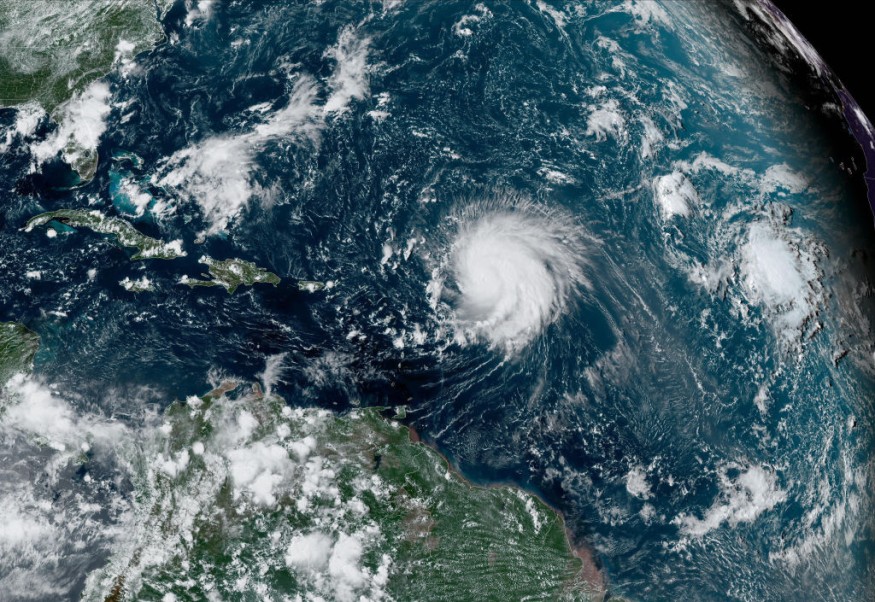
At present, Lee has been under Category 3 based on the Saffir-Simpson Hurricane Wind Scale.
This as data from an Air Force Reserve Hurricane Hunter aircraft indicated that the maximum sustained winds have increased to near 120 mph (195 km/h) with higher gusts.
So far, additional strengthening is seen to happen in the next day or so while some fluctuations when it comes to intensity are possible on Monday and Tuesday, Sept. 11 to Sept. 12.
On the other hand, weather experts said that hurricane-force winds extend outward up to 45 miles (75 km) from the center and tropical-storm-force winds extend outward up to 175 miles (280 km).
Furthermore, the latest minimum central pressure reported by Air Force Reserve reconnaissance is 954 mb (28.17 inches).
According to the latest weather forecast, the swells generated by Lee are affecting portions of the Lesser Antilles, the British and U.S. Virgin Islands, Puerto Rico, Hispaniola, the Turks and Caicos Islands, the Bahamas, and Bermuda.
Meteorologists warned that these swells are likely to cause life-threatening surf and rip current conditions.
So far, risky surf and rip currents have begun to reach portions of the southeast US East Coast.
Officials warned that these surfs and rip currents are expected to worsen and spread northward along much of the US East Coast during the next couple of days.
The National Hurricane Center said the intensity prediction calls for steady intensification during the next 24 hours or so, and that Lee is forecasted to regain category 4 status tonight or early Monday.
After that time, the slow motion of the hurricane could cause the water beneath the hurricane to cool due to upwelling, which is likely to cause Lee's intensity to plateau or weaken slight during the middle portion of the forecast period.
Meanwhile, in the fourth and fifth day, the increasing southwesterly shear is likely to cause weakening, however Lee's wind field is expected to expand by that time.
Lee is forecasted to remain a strong hurricane through most of this week.
New England, Canada impacts
Weather forecasters said that as Lee moves northward in the coming days, impacts are expected in eastern New England and Canada.
The exact track of Lee would determine the scope of direct and indirect impacts in the eastern US as well as in Atlantic Canada.
Meteorologists further explained that the slow forward speed of Lee for a time this week may cause the system to lose some wind intensity as cool water from the depths is churned to the surface.
Related Article : Hurricane Lee Weakens Into Category 3, Lingers in US for 5 More Days
Related Video:
© 2026 NatureWorldNews.com All rights reserved. Do not reproduce without permission.


