Hurricane Lee is forecasted to become a powerful hurricane that could impact parts of the Caribbean, the US East Coast, Atlantic Canada and North Carolina. The hurricane is expected to intensify into Category 5, unleashing torrential rain and strong winds.
People with outdoor plans should prepare for the latest hurricane.The storm is forecasted to strengthen rapidly this weekend.
Hurricane Lee movement: When will it make a landfall?
The hurricane is currently moving west-northeast, around 800 miles from the northern Leeward Islands. According to the National Hurricane Center, Hurricane Lee is yet to make a landfall next week. Currently, it's too early to tell which exact land areas will be hit by the hurricane.
Hurricane Lee's rapid progression into a Category 5 hurricane is triggered by the warm ocean water, moist environment, and lower wind shear. This August, unusually warm water temperatures were recorded in parts of the Atlantic Ocean.
Hurricane Lee's latest impacts
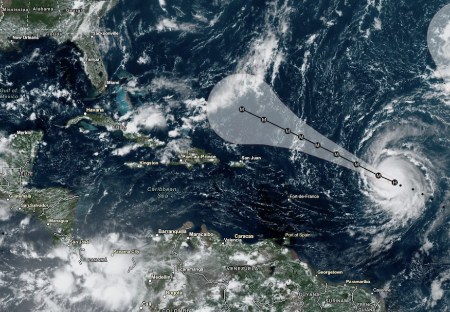
On Saturday, Sept. 9, Lee is expected to bring severe weather conditions to parts of the Northern Leeward Islands. According to the latest forecast, Hurricane Lee developed over the Central Atlantic, as wind shear helped it to strengthen rapidly.
The hurricane is last seen over the eastern portions of the Leeward Islands. On the weekend, residents in the Northeast Caribbean could expect the impacts of Hurricane Lee, including in the following areas:
- US East Coast
- British Virgin Island
- Barbuda
- Antigua
- Anguilla
- Puerto Rico
In the US, weather agencies are monitoring the possible developments of tropical storms. The latest hurricane could likely impact parts of North Carolina and Atlantic Canada. Until next week, the advisory warned of possible rip currents and challenging surf in the following areas:
- Daytona Beach
- Jacksonville
- West Palm Beach
- Savannah
- Charleston
- Wilmington
- Virginia Beach
September is known to become active in hurricanes. It is essential to keep updated with the US's tropical storm and hurricane forecasts. Americans have been recovering from the impacts of Hurricane Idalia that unleashed rainfall flooding in parts of Florida's Gulf Coast. Fortunately, Hurricane Lee is not expected to hit the said areas.
Meanwhile, people have suffered from heatwaves in the Northeast, Mid-Atlantic, Midwest and South-Central. The heat could still persist this week despite the hurricane affecting various US states.
Staying safe from Hurricane Lee
Forecasts showed that September could bring challenging storms and hurricanes. Severe weather conditions could unleash heavy rains, flooding, landslides, flash flood risks and evacuations.
Early preparations are essential to prevent the possible devastating impacts of storms. Here are essential reminders to stay safe from severe weather risks in the US.
Homeowners should monitor the weather for possible weather risks. Turning on your mobile alerts is also recommended, as heavy rain could unload at night.
If you live near a flood-prone area, flooding could be possible. It is essential to evacuate when the floodwaters rapidly rise.
Homeowners can also keep emergency supplies that they can bring to evacuation centers.
Related Article : US Weather Forecast: Hot, Dry Weather To Continue in Mid-Atlantic; Severe Storm Likely in South Dakota
For more similar stories, don't forget to follow Nature World News.
© 2026 NatureWorldNews.com All rights reserved. Do not reproduce without permission.


