The Bureau of Meteorology has issued a warning for heavy rain, flash floods, and potentially destructive hail in regions of Queensland, New South Wales, Victoria, and South Australia.
Storms and giant hail forecast for eastern Australia
 (Photo : WILLIAM WEST/AFP via Getty Images)
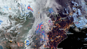
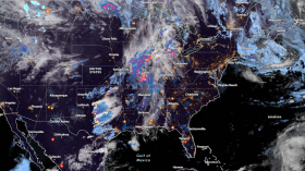
Rain, thunderstorms, and large hail are expected for most of the east coast, increasing the potential of flash floods in regions already experiencing severe weather, as per The Guardian.
Showers and thunderstorms are expected in northern Queensland, New South Wales, northern Victoria, and eastern South Australia through the weekend, according to the Bureau of Meteorology.
The greatest danger will be heavy rain, which will cause flash floods, with damaging winds and big to huge hail possible for inland regions of southern Queensland and interior northern New South Wales, causing car and property damage, according to a statement.
When unexpected storms stormed through New South Wales and Queensland last October, massive hail was witnessed.
It is described as any hailstone larger than 5cm in diameter and is highly rare because it can only develop under certain conditions.
On Sunday night, a low-pressure system is likely to form across central New South Wales, bringing additional rain and storms until Wednesday.
According to the Bureau, the impact on flood-affected regions will be determined by where thunderstorms begin and the direction in which they proceed.
Several serious flood warnings are presently in effect across northern Victoria and New South Wales, with evacuation orders issued for several localities.
After the Patchell Bridge on the Murray Valley Highway was blocked on Wednesday night, residents in the northern Victorian town of Kerang were advised that it was too late to flee.
Echuca and the smaller communities of Barmah, Lower Moira, and Bunbartha are still under evacuation orders, with overflowing rivers threatening to breach their banks.
Locals in Echuca have spent days constructing a two-kilometer homemade flood levee through town to safeguard thousands of homes and businesses.
The federal government announced an augmentation of 500 Australian defense force members to assist with recovery work in Victoria and portions of NSW on Thursday.
Up to 400 ADF members will assist with different activities in Victoria, including sandbag distribution and doorknocking. The remaining ADF personnel will assist in NSW.
Read Also: Australia Weather Update: BoM Forecasts Continuance of Cold Front Into the Weekend
Today's viewing options
Much of the attention today has been focused on Moama and Echuca on the Victoria-New South Wales border, where communities are banding together with sandbags to defend their homes and businesses, as per ABC.
According to senior BoM forecaster Jonathan How, the Murray River is presently 94.4 meters above sea level.
"The 1993 level was 94.77, so [the water] is just around 30 to 40 cm below the 1993 level, but it is increasing and is projected to peak in the next few days."
He predicted that the water level will rise above the 1993 level.
The village of Moama is one of the primary areas of worry for the NSW SES as the Murray River's banks continue to rise.
There is also significant flooding in Echuca, where the SES predicts that the floodwaters will peak tonight and tomorrow early.
Emergency evacuation advisories continue in effect from Barmah to Echuca, according to SES chief operating officer Tim Wiebusch.
Kerang, to the northwest of Echuca, has already been shut off from the rest of Victoria, with the Loddon River predicted to create catastrophic flooding later today.
It is predicted to exceed 2011 flood levels, although the water will remain below the levee.
Kerang will be isolated for at least seven days, according to Mr. Wiebusch.
What to look forward to tomorrow and beyond
A low-pressure system predicted over the weekend and early next week, according to the Bureau of Meteorology, will bring even more rain.
A current low-pressure system is already pouring heavy rain in Queensland and is expected to pass over flood-stricken northern Victoria in the coming days.
Following that, senior forecaster Jonathan How stated that further rain was anticipated.
The worst rains were forecast to fall on Saturday, according to SES Deputy State Duty Commander Ken Murphy.
In terms of the southern half of the state, the weather event that will occur on Saturday is most likely to create larger river rises, as well as additional isolations and severe road closures.
Severe thunderstorms are anticipated to wreak havoc throughout most of eastern Australia, from Central Queensland to northern Victoria.
In Tasmania, the BoM is warning residents to brace themselves for a lengthy rainstorm in the coming week.
Rain will return to the northern and eastern parts of the state tomorrow before a second system brings widespread rain to the majority of the state on Saturday.
This rain will continue throughout next week, with some places anticipating at least 100 mm, putting more strain on waterlogged river catchments.
Related Article: Australia Will Experience More La Nina Weather This 2022
© 2024 NatureWorldNews.com All rights reserved. Do not reproduce without permission.