In just a few days, when a strong cold front rips across the northeastern United States, a volatile weather pattern could increase the possibility of winter-time snowfall to summer-like heavy thunderstorms.

First Frost of the Season
The first frost of the season for some more southerly places occurred on Sunday morning when temperatures fell below freezing, and widespread frost covered sections of New England and New York, Pennsylvania, West Virginia, Kentucky, and Virginia. Sunday morning had a low of 31 in Lexington, Kentucky, and 34 in Charleston, West Virginia.
This week's first half will return to almost average temperatures.
The mild weather is forecast to be at its mildest for places like Pittsburgh, Detroit, and Buffalo, New York, on Tuesday and Wednesday, when afternoon temperatures might surge as high as 10 degrees above average into the 70s.
Change in Temperature
Wednesday will be the hottest day for the Eastern Seaboard, with highs in Boston and Richmond, Virginia ranging from the low to mid-seventies. During the hottest afternoon hours, a few locations farther south in North Carolina might reach 80 degrees. As well as being up to 10 degrees above average for the middle of the month, these temperatures will be closer to those of a typical day in the third week of September.
Wednesday afternoon would be a terrific time for most people in the area to spend outside, whether it be pumpkin harvesting, hiking, or leaf-peeping.
But there will be another sign that winter is approaching quickly, lurking behind the warmth of mid-October.
Also Read: From Midwest to Northeast, Certain Regions in America May Get an Early Taste of Winter
Cold Wind
According to AccuWeather meteorologists, a strong cold front with some chilly Canadian air is predicted to move over the eastern part of the United States this week.
This week, a strong cold front will be followed by a rush of cold air, which will cause temperatures to plummet, according to AccuWeather Meteorologist Brandon Buckingham.
By Wednesday, the cold air mass is expected to move into the northern Plains before moving to the Great Lakes and Ohio Valley.
According to AccuWeather meteorologists, a strong cold front with some chilly Canadian air is predicted to move over the eastern part of the United States this week.
By Wednesday, the cold air mass is expected to move into the northern Plains before moving to the Great Lakes and Ohio Valley.
The Ohio Valley and Northeast are anticipated to experience sharp weather fluctuations, with maximum temperatures plunging as much as 15 degrees in only a few days.
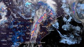
This front will go through with more atmospheric moisture than most frontal crossings have so far in October, bringing more widespread showers and thunderstorms.
The cold air and precipitation farther north will probably cause snowflakes to fall in the Great Lakes region. While Minnesota and Wisconsin are likely to get the greatest snow, some may also be in some areas of Michigan and New York.
Weather Changes
A major alteration that may increase atmospheric instability and the risk of severe weather is the collision of the cooler air ahead of the front and the cold air behind it.
On Thursday, as the front moves eastward, gusty showers and thunderstorms may accompany it across the Northeast and mid-Atlantic. Also possible are isolated cases of small hail.
Travelers should be aware of these wind gusts since they can make driving at high speeds challenging or even dangerous, especially for those in high-profile cars.
Related Article: Exposure to Major Disasters Can Cause Long-Term Mental Health Problems
For more climate and weather updates, don't forget to follow Nature World News!
© 2024 NatureWorldNews.com All rights reserved. Do not reproduce without permission.