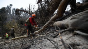
The Mosquito Fire engulfed a total land area of approximately 64,000 acres as of Thursday, September 15, becoming California's largest wildfire in 2022 so far.
Erupted over a week ago, the wildland fire continues to rage on in the counties El Dorado and Placer, causing widespread disruption to road travel and to infrastructure.
The growing blaze also forced the issuance of evacuation orders for residents.
The Mosquito Fire is only one of the many active wildfires across California and other states in the Western US, including Washington, Oregon, and Idaho in the Pacific Northwest.
The simultaneous fire events prompted local authorities to declare poor air quality in the region, which suffered from a series of extreme heat waves, unusually dry conditions, and high temperatures in recent weeks and months.
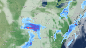
This year's largest California fire persisted in spite of recent weather forecasts that there will be a Western rainfall and drought relief in the US region this week.
The forecasts also expected the increased flooding risk due to a tropical moisture linked to the North American monsoon.
While the anticipated wet weather may cool down the West, it is not clear if it will be enough to mitigate or dose off the massive wildfire.
Mosquito Fire

The California Department of Forestry and Fire Protection (Cal Fire) states the Mosquito Fire has exactly burnt at least 64,159 acres and is only 20% contained as of 4:27 p.m. local time on Thursday.
It is currently burning between Mosquito Road and OxBow Reservoir, located east of Foresthill, Placer County.
Also known as the Foresthill Dutch Flat Fire, the Mosquito Fire has destroyed 70 structures and damaged 10 structures, including residential and commercial establishments after being active for eight consecutive days.
There were no direct reports of fatalities or injuries.
Wildfire Evacuation Orders
According to Cal Fire, evacuation orders are in place for the following zones in Placer County:
- Michigan Bluff
- Baker Ranch Mobile Home Park
- Downtown Foresthill
- Todd Valley
- Sierra Vista Mobile Home Park
- North Side of Foresthill Road
- Spring Garden/Whitehawk Ridge
- Yankee Jims and Shirttail Canyon
For El Dorado County, the following evacuation orders remain in effect:
- Volcanoville
- Quintette
- Bald Mountain
- Grey Eagle
- Canyon Creek
- Georgetown
- Stumpy Meadows
Largest California Fire
The Golden State's largest fire is being dealt with by over 3,500 active fire-fighting personnel who were working alongside with units from multiple areas, including from El Dorado, Foresthill, and Tahoe, according to AccuWeather.
Cal Fire released a status update that firefighters were successful in controlling fire growth along the communities in Foresthill and Todd Valley.
The main focus of the operation is around the south and east sides of the fire, as part of measures to secure control lines.
The Mosquito Fire is said to have been fueled by a "historically dry vegetation" worsened by the historic heat wave last week, according to Scott McLean, spokesman for Cal Fire, as cited by the Los Angeles Times.
Related Article: Mosquito Fire in California Burns Through Homes and Vehicles; Over 11,000 People Remain Evacuated
© 2024 NatureWorldNews.com All rights reserved. Do not reproduce without permission.
![Wildfire Activity in Wet African Tropical Forests Exacerbated by Deforestation, Climate Change [Study]](https://1471793142.rsc.cdn77.org/data/thumbs/full/70409/280/157/50/40/wildfire-activity-in-wet-african-tropical-forests-exacerbated-by-deforestation-climate-change-study.jpg)