For parts of northeast California, Reno, and portions of northwest Nevada, there is a Fire Weather Watch in effect from Saturday afternoon until early evening due to gusty winds and low humidity. As early as Thursday, August 25, the National Weather Service issued the alert. The alert is currently at a moderate level.
On Saturday, winds will be blowing from the southwest to the west at 15 to 25 mph with gusts of 30 to 40 mph and humidity of 8 to 15 percent.
The alert is anticipated to last between three and seven hours.
Fire weather Watch for Nevada and parts of California. Low RH and gusty winds. #wildfire #fire #weather #Nevada #California pic.twitter.com/nC7wjRd1Pc
— The Hotshot Wake Up (@HotshotWake) August 25, 2022
Experts point out that low humidity and gusty winds can cause fires to spread quickly and become more intense before the first responders can put them out.
It is advised to Avoid engaging in outdoor activities that could start a fire near dry greenery, such as shooting targets outside or using fireworks, leaving lit campfires unattended, dragging trailer chains, or driving over dry grass.

Scorching Heat at the Valley of Fire, Nevada.
North Eureka and Lander Counties north of I80, Fire Weather Zone 438: West Elko County, Fire Weather Zone 437: Humboldt County-Quinn, and other areas are affected, the National Weather Service reports.
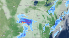
A live map of the areas where alerts are being issued has been posted by Nevada Fire Info.
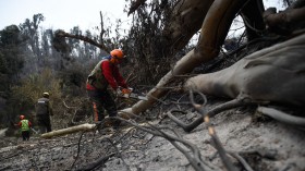
CAL FIRE will increase the number of firefighters on duty, man more fire engines, and keep more equipment operational around-the-clock during times of increased fire danger so that it can respond to any new fires that may break out. Californians are urged by CAL FIRE to exercise extreme caution, particularly when there is a high risk of wildfires. It is critical that all locals and visitors take precautions to avert wildfires and keep in mind that one fewer spark could result in a smaller wildfire.
Fire Weather Watch, Red Flag Warning
All locals and visitors must take precautions to avert wildfires and keep in mind that one fewer spark could result in a smaller wildfire. A Fire Weather Watch could be issued for the following 12 hours in cases of dry lightning.
There are four levels of Fire Weather Watch, namely minor, moderate, major, and extreme.
The National Weather Service issues either Red Flag Warnings or Fire Weather Watches to inform fire departments of the arrival or potential arrival of critical weather as well as dry conditions that could cause wildfire activity to increase dramatically or quickly. When dry fuels and weather support an extremely high fire risk, a Red Flag Warning or Fire Weather Watch is issued. To emphasize the elevated fire risk, these materials are documented for land and fire managers.
Each NWS office develops regional standards for red flag and fire weather alerts.
A Red Flag Warning is issued when the aforementioned conditions are expected to or are occurring sometime in the next 24 hours, as opposed to a Fire Weather Watch, which is issued up to 72 hours before the aforementioned conditions are anticipated to occur.
Related article: Texas Dries Up Midweek, High Chance of Flooding Rains Sunday Night in Dallas Area
© 2024 NatureWorldNews.com All rights reserved. Do not reproduce without permission.
![Wildfire Activity in Wet African Tropical Forests Exacerbated by Deforestation, Climate Change [Study]](https://1471793142.rsc.cdn77.org/data/thumbs/full/70409/280/157/50/40/wildfire-activity-in-wet-african-tropical-forests-exacerbated-by-deforestation-climate-change-study.jpg)