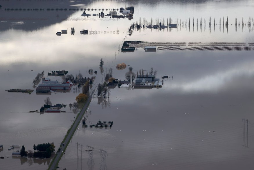
Floodwaters have gripped some areas in British Columbia in the past several weeks as of Wednesday, June 29, submerging both residential and commercial establishments, as well as fields and roads.
Provincial authorities have issued a new flood watch, high stream advisories, and evacuation alerts in the affected areas.
The implemented flood-related measures meant that flash flooding in the province is not only disruptive but also life-threatening.
The risk is manifested by rapid melting of ice and snow on mountains and along inland bodies of water.
Furthermore, flood levels could also rise quickly, oftentimes in an unpredictable manner.
These threats were previously introduced through warnings issued by meteorologists and hydrologists in the province, including the B.C. River Forecast Centre (RFC), in May 2022.
The warnings pertain to the issuance of weather predictions relating to the B.C. flood risk after mountain snowpack accumulation was above-normal average levels.
The current climatic situation in B.C. is one of the worst natural disasters reported in Canada.
In addition to heavy rain, the unprecedented flooding from melting frozen ice is still a threat.
These risks affect both residents and local officials as previously highlighted from the warnings of B.C. RFC experts, regarding the aggravation of melting through heat wave or hot weather.
B.C. Evacuation Alerts
Local authorities have issued evacuation alerts as a recent torrential rain due to inclement weather released a heavy downpour across the central and southern B.C. areas, leading to the snow melt.
This led to the renewed flood alert or flood watch, as well as high streamflow advisories, according to Global News.
The Fraser Valley Regional District (FVRD) issued an evacuation alert for Jones Creek, Wahleach Creek, and Lorenzetta Creek in Laidlaw on Wednesday. Additional areas affected by the alert are:
- Harrison Mills in Electoral Area C
- Nicomen Island
- North Nicomen
- Taylor Road
Current advisories were also issued for Harrison and Frser River undiked lands on Monday, June 27.
The FVRD also mentioned that sand and sandbags are available for residents in the affected areas. It has also activated the Emergency Operation Centre (EOC) at Level 1.
The district authority said it is monitoring both current and forecasted river levels, through data from the B.C. RFD and weather forecasts from Environment Canada.
B.C. Flood Alerts
Flood alerts reportedly remain in effect for dozens of residential and commercial properties in the Glen Valley areas within Abbotsford and Langley.
There are also 40 properties in Harrison Mills and select houses in Northwest Langley and Fort Langley under the alert.
Township of Langley officials on Wednesday afternoon also urged residents to be prepared for an evacuation order, a mandatory mandate compared to the less restrictive evacuation alert.
Details of the evacuation notice will be disseminated by protective services staff to low-lying and unprotected areas.
There were no immediate reports of deaths or injuries from the B.C. flooding.
Similar to the United States, Canada is currently in its summer season which normally spans from June to August each year.
© 2026 NatureWorldNews.com All rights reserved. Do not reproduce without permission.


