AccuWeather forecasters predicted that the Pacific Northwest will have its coldest New Year's Eve in years this week, as heavy snowfall continues to blanket Seattle, Washington, and Portland, Oregon.
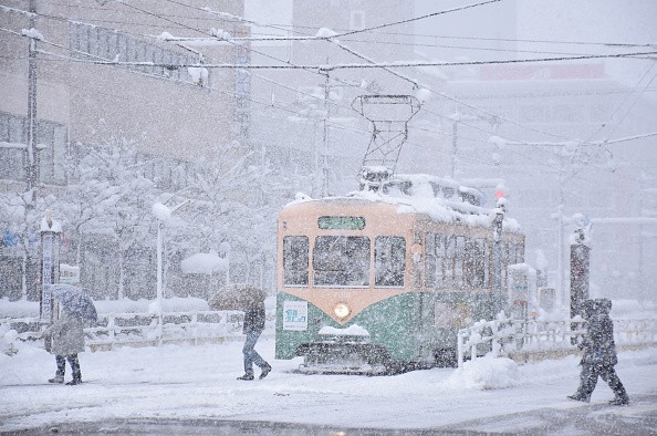
Winter Storm in Seattle, Portland
Despite the fact that it's just been a few days since Seattle saw its lowest temperature since 2010, the city and the Interstate 5 corridor have been blanketed with snow.
Even into the beginning of 2022, experts predict the cold and snowy trend in the Northwest is projected to persist through 2021 and into the new year, according to Accuweather.
This weekend is going to bring additional rounds of slick driving and walking conditions. The wintry attack is aimed at interstates 5, 84, and 90, which together cover a large area. During storms, drivers can expect to experience patches of snow and ice on these roadways
A combination of rain and snow is expected along the coastlines of Washington and Oregon, with local accumulations of a coating to an inch likely on Thursday.
Storms are expected to return for New Year's Eve celebrations along the coastlines of Washington and northern Oregon, dumping a mixture of snow, sleet, and rain on the festivities Friday night.
Snow, Rain Expected to Impact Washington
A few inches of snow might fall over the mountains and the Olympic and Cascade ranges before the end of the year, according to experts. Road conditions could be treacherous for travelers intending to drive.
In eastern Washington and Oregon, overnight temperatures will fall into the single digits and teens F. The coasts of both states, on the other hand, will be frigid, with low to mid-20s in northwest Washington and upper 20s and lower 30s in southwest Oregon at midnight.
On December 31st, the average high temperature in Seattle is 47 degrees Fahrenheit, while the average low temperature is 37 degrees Fahrenheit.
The average high and low temperatures in Portland are 46°F and 36°F, respectively. Temperatures are expected to be in the 30s in Seattle today, while Portland is expected to be in the mid-30s.
Series of Storms May Hit Pacific Northwest
Late Saturday night and into New Year's Day, warmer Pacific Ocean air is expected to flow inland, bringing with it rain and/or drizzle and above-freezing temperatures to most coastal places. However, with the return of cold air on Tuesday, the stage will be set for further snowy weather along the coast.
The Pacific Northwest will be impacted by a series of storms from Jan. 2 to Jan. 6, AccuWeather Senior Meteorologist Dan Pydynowski said, noting that it will stay colder than normal, so snow will be possible at lower altitudes west of the Cascades.
Forecasters from AccuWeather's long-term team of meteorologists believe that the current trend of below-average temperatures and above-average precipitation in the West will continue until mid-January.
The long-term drought in parts of the West will continue to be hammered by the pattern. However, floods and mudslides may occur when rain falls at intermediate altitudes during transient warm air incursions.
For more news, updates about winter storms and similar topics don't forget to follow Nature World News!
© 2026 NatureWorldNews.com All rights reserved. Do not reproduce without permission.


