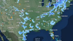
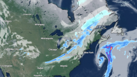
Meteorologists at AccuWeather are keeping a careful eye on the Atlantic basin for the possibility of two named storms developing in the coming weeks. The Atlantic hurricane season has only been underway for a week, yet things are lining up in such a way that two storms might form, both in entirely different parts of the basin.

Forecasters have identified one region over the Gulf of Mexico, another over the western Caribbean Sea near Central America, and a stretch off the East Coast of the United States near the Carolinas as possible danger zones. There's even a 50 percent probability that a disturbance may emerge and intensify over the eastern Pacific Ocean in the coming weeks, influencing how things play out.
Regardless of whether it builds into a tropical storm or not, any disturbance that develops off the East Coast is expected to go out to sea. However, suppose a tropical storm emerges around Belize or southern Mexico. In that case, it may move northward into the United States' Gulf Coast, a region of the country that has been prone to flooding due to recent heavy rains.
Related Article: Atlantic Hurricane Season 2021: Here's What to Expect
Gyre

A gyre, or a vast circulation region that causes air pressure to dip below its surrounding environment, is forecast to occur, allowing thunderstorms to erupt. Thus, a tropical system can gradually assemble whenever thunderstorm complexes form and persist over warm seas.
Wind Shear
A decrease in wind shear is another aspect that will increase the likelihood of tropical growth. But, according to Senior Meteorologist Dan Pydynowksi, a combination of variables might be the impetus for development. "Lowering wind shear, warm water, and a moistening environment may be enough," he added, to develop anything strong enough to be recognized.
Wind shear is the shift in direction and speed of winds at various altitudes of the atmosphere, and it can stifle the development of tropical systems and impact their path. While tropical systems can form when wind shear is severe, most tropical systems arise when wind shear is moderate.
Tropical Storms Bill and Claudette

Bill and Claudette are the next two tropical storms on the list for the 2021 season. Ana, the first name on this year's list, formed on May 22 and dissipated on May 24 over the central Atlantic.
On the Atlantic side, if a tropical system forms around Central America or southern Mexico, forecasters contemplate several options following development.
Possible Trajectory
One possibility is that the system will just travel inland over Central America or southern Mexico, then fade away.
In a second possibility, the system might drift northwestward over land and re-emerge over Mexico's southern Gulf, regaining power. A third scenario, which is becoming increasingly likely, is that the system originates over the south of the Gulf of Mexico rather than the Caribbean Sea. As a result, meteorologists upgraded the risk of development to roughly 50% on Thursday afternoon.
Another option mentioned by meteorologists is that tropical development might occur along the coast over the Eastern Pacific. That storm may then travel inland and spin-off a system on the Atlantic side, similar to what Amanda did last year about this time with Cristobal.
Because it crosses from one basin to another, the occurrence is also referred to as a crossover storm. As of Thursday, the chances of this situation occurring seems to be dwindling.
Also Read: Storm Anxiety: How to Handle Extreme Weather Phobias During Hurricane Season
For more climate and weather updates, don't forget to follow Nature World News!
© 2024 NatureWorldNews.com All rights reserved. Do not reproduce without permission.