Scientists have released astounding night images of the Earth captured by a NASA and National Oceanic and Atmospheric Administration (NOAA) satellite.
The images were released during a news conference at the American Geophysical Union meeting in San Francisco.
Many satellites have taken images of the Earth illuminated by the Sun during the day, but the NASA-NOAA Suomi National Polar-orbiting Partnership (NPP) satellite, which was launched last year, has a sensor that can help scientists to see images taken at night.
The sensor, the day-night band of the Visible Infrared Imaging Radiometer Suite (VIIRS), is very sensitive and can detect the night-time glow produced by the Earth's atmosphere and even a light from a single ship in the sea with better resolution, says NASA.
"For all the reasons that we need to see Earth during the day, we also need to see Earth at night," Steve Miller, a researcher at NOAA's Colorado State University Cooperative Institute for Research in the Atmosphere, said in a statement. "Unlike humans, the Earth never sleeps."
The VIIRS sensor scans a particular scene repeatedly and then resolves them into individual pixels. If the pixel is bright, a low-gain mode prevents it from getting over-saturated. In case the pixel is dark, the signal is improved. This way, the satellite is able to take high resolution images of the Earth's atmosphere, land and ocean surfaces at night time, even without moonlight.
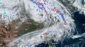
VIIRS day-night band images provide data to scientists about a variety of unseen or poorly seen events. Last month, the sensor captured the night-time view of some of the East Coast areas to reveal the extent of power outage caused by Hurricane Sandy. Sandy made its landfall on the coast of New Jersey during the night of Oct. 29.
The sensor took images showing night-time view of the mid-Atlantic areas including New York City, New Jersey and eastern Pennsylvania. Apart from this, it also gives better views of weather conditions that are difficult to detect using thermal, sensors and infrared light.
"NOAA's National Weather Service is continuing to explore the use of the day-night band," said Mitch Goldberg, program scientist for NOAA's Joint Polar Satellite System. "The very high resolution from VIIRS data will take forecasting weather events at night to a much higher level."
Check out the video below:
© 2024 NatureWorldNews.com All rights reserved. Do not reproduce without permission.
![Microplastics Escape Body's Gut to 'Infiltrate' the Brain, Kidneys and Liver [Study]](https://1471793142.rsc.cdn77.org/data/thumbs/full/70195/280/157/50/40/microplastics-escape-bodys-gut-to-infiltrate-the-brain-kidneys-and-liver-study.jpg)