Wildfires are a serious problem across the Western United States, and each case has threatened homes, businesses, and even the natural landscape. But what if something can detect wildfires beforehand?
It can be remembered that despite the natural beauty of the region that inspires so many people to visit and live there, wildfires tend to be a very real and dangerous threat.
Steven Brumby, currently taking his post doctorate at Los Alamos National Laboratory, started growing interested in developing machine learning tools to map wildfires around the world after a wildfire almost destroyed his home in 2000.
However, it appears current developments in new satellite technology, cloud computing, and machine learning are slowly making this possible.
According to Medium, it's first important to understand that over the last 30 years, larger and more intense fires have damaged millions of acres of land.
The U.S. Forest Service has estimated that 90 percent of these fires were even caused by humans. While the US has resources to fight most wildfires, some remote locations may not even be detected for days.
Climate studies show that wildland fires are a significant contributor to greenhouse gas emissions as well, with 50 percent of human industrial emissions being from them.
However, it appears mapping wildfires around the globe is a possibility. The technology of fire detection has slowly evolved from located watch towers in the 1990s, to manned spotter aircraft in the 1950s and satellites from 1970s to the present.
The latter is a key to consistent global scale fire detection, however, current sensors only detect fires that have reached a substantial size. Meaning this isn't too useful than ground and aircraft systems for early detection.
Satellites from the U.S. and EU have thermal sensors that can detect the heat of wildfires from orbit, allowing daily mapping of these wildfires globally, except if they are masked by clouds.
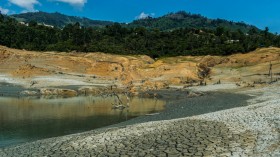
The "scars" by wildfires are also visible from space and provide a way to "map" the slow recovery of ecosystems and determine what was lost in the fire.
This means that mapping is not only important. It is also important to map tree health and risks to nearby residential and infrastructure zones as well.
Now, Brumby has helped develop a generic algorithm-based machine learning approach to "teach" computers to map wildland fire burn scars. They originally used satellite imagery from NASA, which was a hard thing to do at the time as someone from a data center has to cut at least a 400MB Landsat file to a CDROM and mail it physically.
Now, at Descartes Labs, they have a platform to analyze all the world's public and commercial satellite imagery using the cloud and machine learning.Google and Amazon is currently hosting NASA/USGS, NOAA and ESA satellite imagery archives, meaning they can now process more data than before.
This enables their scientists to analyze virtually all the available imagery across different satellites. For instance, they were able to process more than a hundred times the data used in their weeks-long work on the Cerro Grande fire and finished analysis in just an hour.
Meaning, there is a new era coming in the field of global monitoring, historical analysis, real-time altering and forecasting the future.
© 2024 NatureWorldNews.com All rights reserved. Do not reproduce without permission.